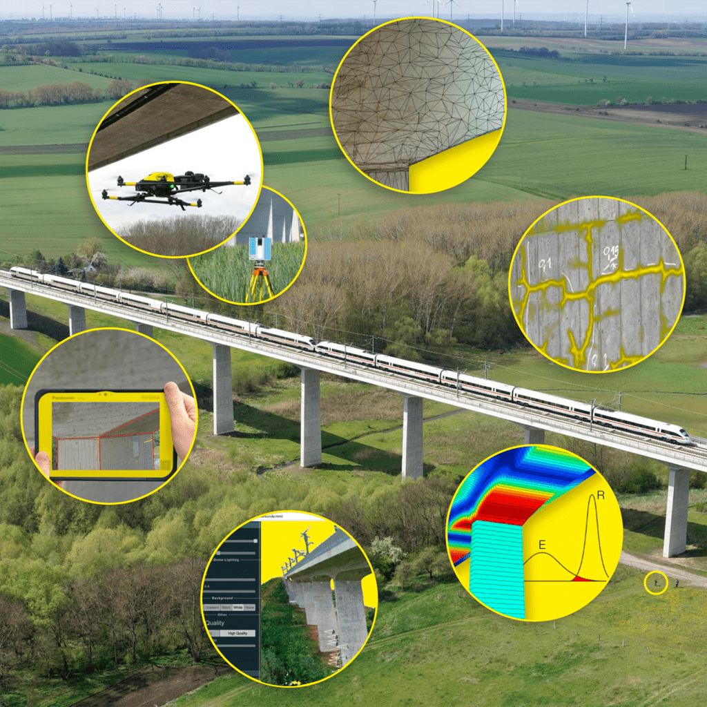
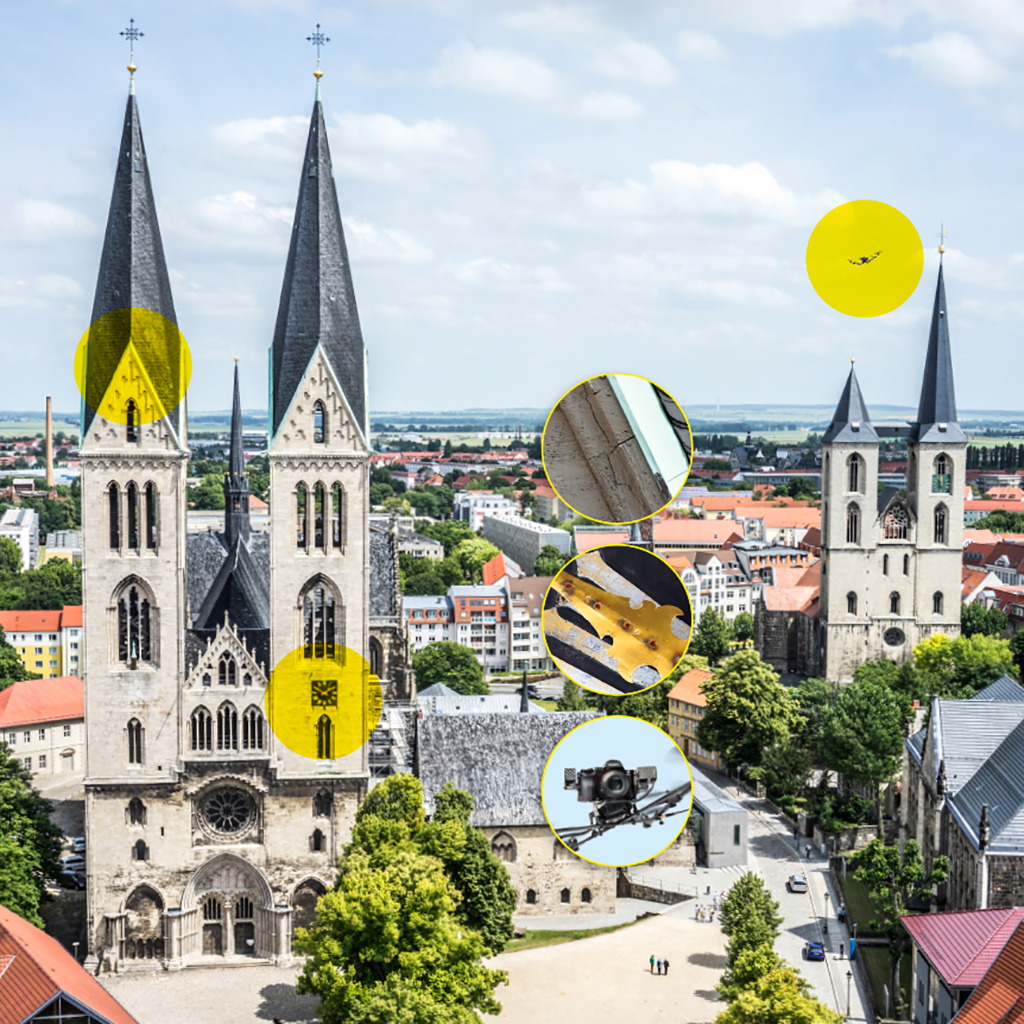
Inspection, diagnostics and continuous condition monitoring are key elements in the maintenance of structures. We have specialised in the application of UAS technology for remote visual sensing of structures. Using cutting edge professional UAS we provide a range of services based on expertise from various research projects and experience gained from inspections of a wide range of structures such as bridges, dams, wind turbines and historical buildings.
Our UAS systems are equipped with high-performance cameras for capturing still images as well as providing HD live video streams for inspection purposes. This allows for a rapid, safe and cost-effective acquisition of high quality visual data that can be used for a large range and post processing purposes.

In numerous condition assessment projects we have been able to perform extensive inspections on structures using UAV and have continuously widened the scope of possible applications of UAV in structural diagnostics through research and development activities. Today we can offer a range of services that allow for a tailor-made documentation of structural state and change detection. The key applications and data processing methods are listed below. Prospective clients can expect a detailed strategy for diagnostic services to be developed for their structures.

Our developed methods provide an efficient support for hand-held testing in accordance to DIN 1076. Thus minimize the downtime of the structure and reduce the operating times and risks of personnel on the structure. Our service portfolio covers the entire digital process chain from data acquisition and preparation to data evaluation and fully digital semantic storage to condition assessment and visualization of all structural and condition data over the life cycle.

UAS-based automatic recording of structures

  • High-resolution photos
  • Thermography

Geodetic survey of structures

  • Tacheometry
  • GNSS measurement
  • laser scanning

Generation of geo-referenced building models

  • 3D point clouds
  • Meshed and textured 3D building models
  • BIM models
  • Finite element models for numerical simulations

AI-supported image analysis

  • Automated damage detection using machine learning methods
  • 3D localization of damages
  • Damage referencing on 3D building models

Data interpretation for condition assessment of structures

  • Numerical simulations for structural analysis
  • stability assessment, e.g. according to the calculation guidelines

Cloud for digital infrastructure maintenance

  • Web platform for building models and status data
  • Systematic storage of all data in the life cycle
  • Predictive asset management

Documentation and visualization of structures and condition data

  • High-resolution orthophotos
  • Building plans
  • Web-based services
  • VR and AR visualization

Our developed methods provide an efficient support for condition assessment of heritage objects enable a minimization of special access equipment and a reduction in the operating times of specialist personnel on the building. Our service portfolio covers the entire digital process chain from data acquisition and preparation to data evaluation and fully digital semantic storage to condition assessment and visualization of all structural and condition data over the life cycle.

UAS-based automatic recording of structures

  • High-resolution photos, as well as of the Interior of buildings
  • Thermography

Geodetic survey of structures

  • Tacheometry
  • GNSS measurement
  • laser scanning

Generation of geo-referenced building models

  • 3D point clouds
  • Meshed and textured 3D building models
  • BIM models
  • Finite element models for numerical simulations

AI-supported image analysis

  • Automated damage detection using machine learning methods
  • 3D localization of damages
  • Damage referencing on 3D building models

Cloud for digital infrastructure maintenance

  • Web platform for building models and status data
  • Systematic storage of all data in the life cycle
  • Predictive asset management

Documentation and visualization of structures and condition data

  • High-resolution orthophotos/ image plans
  • Building plans
  • Web-based services
  • VR and AR visualization

Further Services

  • Aerial photos and 360 ° panoramas for documentation of construction progresses
  • Aerial photos to support construction management, logistics and security
  • 3D point clouds and 3D models for assessing geometric deviations
  • Aerial photos and detailed images for securing evidences
  • Image-based recording of the actual geometry and surface after completion of the building for handover documentation